Trumpington Meadows Country Park and Nature Reserve and Byron’s Pool
The River Valley South West of Trumpington
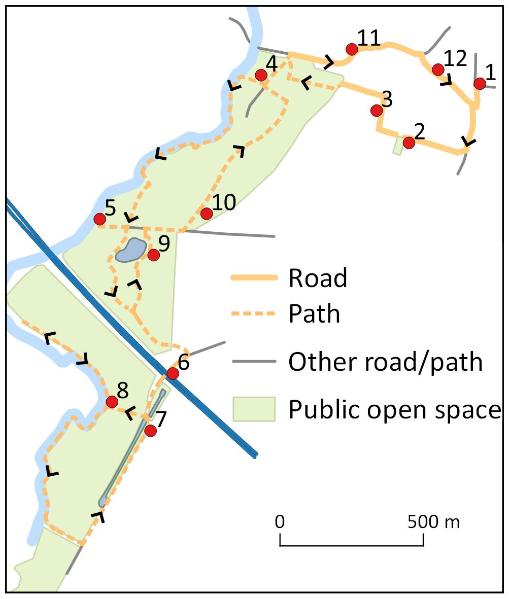
Walk or cycle approximately 5 miles/8 kms: walk on pavements and paths including riverside paths; cycle on roads and dual use paths to and from Byron’s Pool (stops 4 and 11)
This is one of a series of history trails about Trumpington and its links to surrounding villages and Cambridge. We hope that long-established and new residents will find the trails to be a fascinating way to discover more about the history of the area.
The trails have been developed by the Trumpington Residents’ Association and the Trumpington Local History Group, with support from Cambridge City Council. The project is led by Andrew Roberts and Howard Slatter. Thanks to the Wildlife Trust and former PBI staff for contributions to this trail.
Printed copies available free of charge from The Clay Farm Centre and Trumpington Pavilion.
Contact the Local History Group with feedback: admin@trumpingtonlocalhistorygroup.org .
Download a PDF version of the trail or continue with the route …
1. Start at the green by the shops, Anstey Way
2. Trumpington Meadows and Anstey Hall
This is Old Mills Road (named after a field on Anstey Hall Farm). The Trumpington Meadows development will include 1200 homes, the first of which were completed in 2012. Continue to the open space, with views to the right to the church tower and Anstey Hall (Feature A). This boundary and the hall grounds have been lain out in this way for over 200 years (they are shown on the 1804 inclosure map). The play area and apartments (Anstey View) to the left were completed in 2014. Go along Proctor Drive then turn right into Piper Road: ‘Proctor’ was a spring barley and ‘Maris Piper’ a potato variety, both bred by the Plant Breeding Institute (Trail 3).
3. The Saxon settlement and Country Park
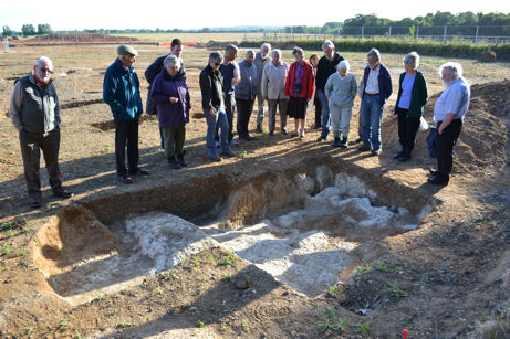
When the area to the left was excavated in 2011, archaeologists found evidence of a Saxon settlement, including houses and graves, one with a bed burial dated to around 650 AD (Feature C). The village developed nearby, including the church where the current building dates from around 1200 AD. Go to the far end and turn left: Anstey Hall Farm is to the right, with new homes built in its grounds in 2016. Continue ahead into Trumpington Meadows Country Park and Nature Reserve, open in 2015 (Feature D). Take the path downhill past the site of new allotments on the right, to a Garden of Reflection planted in 2016, with orchard trees, pond and sculptures. Look out for additional sculptures in the park. Go right to the access road into Byron’s Pool and turn left into the car park.
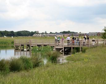
4. Byron’s Pool Local Natural Reserve
Byron’s Pool is the wooded area along the riverside (Feature B). There are four apple trees in the verge along the right hand edge of the car park, planted in 2014 by the Cambridge Community Collection project, the first of which is from Isaac Newton’s apple tree. Go to the far end of the car park (leave bikes here). Take the path to the right to the river, follow the river bank to the left, to the pool, a fish pass and weir. The stream on the far side of the weir is the water course for Grantchester Mill (Trail 9). Continue along the river bank with fish ponds on the left, turn the corner and take the nearby exit to the right into the Country Park.
5. Railway line and railway bridge
Go right on the path across the park. This crosses the site of a Roman farm. At the embankment, turn right to a viewpoint over the river. In the Saxon period, the river divided Mercian territory across the river from the Angles this side of the river. The embankment was built for the Cambridge-Bedford railway, opened in 1862, closed in 1968, after which the river bridge was demolished at the request of the PBI. Go back along the embankment: the former railway route can be seen continuing across the park. The white and orange poles mark a gas pipeline. Before reaching the pond, take the path to the right and follow this around the pond. Take the right fork which goes parallel with the earth bank, raised in 2014 to screen the park from the motorway. Continue to a concrete path and turn right to the bridge over the motorway (Trail 7).
The M11 opened in 1979 and this bridge was used by the PBI to access the further part of its estate, with fields used for crop trials. The route opened to the public in 2014 as part of a cycle link from Trumpington to Hauxton. Looking right, the line of trees from left to right is on the banks of the river. The steel fence along the left hand side of the motorway was designed to screen the radio telescopes at the Mullard Radio Astronomy Observatory from interference from traffic. Look along the motorway and just to the left: it may be possible to see the radio telescopes on the old railway route in the distance, beyond the buildings of Cantelupe Farm in Haslingfield. Continue down the path to a platform by a pond.
7. World War I coprolite pond
The water has filled a deep trench dug during World War I. The local subsoil includes clay with pebbles known as coprolites which have a high content of phosphate, unfortunately not ‘dinosaur dung’! Large parts of the parish were dug in the mid 1800s, when the phosphate was used as fertilizer. This area was exploited late in World War I when phosphate was needed for munitions, although with limited success. Turn back a short distance and take the path to the left alongside the fence across the meadow.
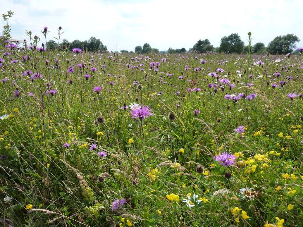
8. Nature Reserve, meadows and riverside
The meadows have been created by the Wildlife Trust using native species suited to local soils, knapweeds, scabiouses, daisies and trefoils, which provide nectar and pollen for beetles, butterflies and bees. Continue to the river bank, this is the Granta branch of the Cam. From here, there is a walk to the right along the river bank to picnic benches. Willow pollards and alders line the river, where a flash of blue could be a kingfisher and otters may leave signs along the river edge. Return to the point where the surfaced path came from the left. Either return to the coprolite pond or continue ahead on the grass path along the river bank, around what was a traditional water meadow. On reaching a stream, go away from the river back to the cycle path, turn left and go alongside the coprolite pond. Go back over the bridge then left and follow the path to the right to the platform over the pond.
9. Balancing pond, wildlife habitat
The pond takes excess surface water from the housing development and releases it slowly into the river. The pond is home to dragonflies, newts and toads and there may be birds feeding on or over the water. A range of aquatic plants has colonised naturally or been planted by the Wildlife Trust. Go left to the railway embankment, turn right for a short distance then take the path to the left across the park.
10. Northern part of Country Park
Continue on the path towards Byron’s Pool. This parkland has been created since 2009, with trees planted from 2012. There are a number of art features across the area, including fallen trees used as bike racks. Return to the car park to collect bikes. Go to the exit onto Grantchester Road, then to the right and uphill (Trail 1).
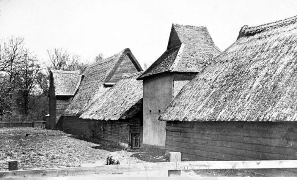
11. Anstey Hall Farm and Parish Church
Anstey Hall Farm is on the right, with newly converted buildings including a former threshing barn and dovecote, both dated 1600s-1700s. Around the corner, the core of the farm house dates from the 1600s and the garden wall is early 1800s. The trees to the left screen Trumpington Hall, on the site of one of the Medieval manor houses. Continue past the church, with homes to the left dating from the 1600s and early 1700s. A short distance from the Saxon settlement, this area developed as the heart of the Medieval village (Trail 1). Continue along Grantchester Road then turn right into Maris Lane.
The entrance to the right is to Anstey Hall, built on the site of another of the manor houses. Go along Maris Lane past Maris House on the left, the home of the Maris family from the 1770s to 1867, whose name was adopted first for the road and then for many of the crops bred by PBI (Trail 1). Continue to the junction and go to the pedestrian crossing to return to Anstey Way.
A. Anstey Hall and Anstey Hall Farm
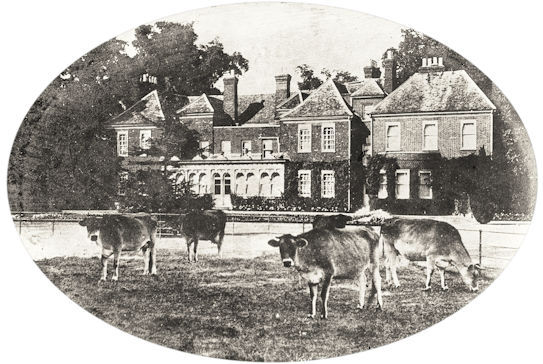
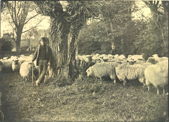
The trail passes the rear and front of Anstey Hall (stops 2 and 12). The ‘Anstey’ name comes from the family who owned the estate from 1748-1838. The current hall was built about 1670 on the site of a Medieval manor house and is now a conference centre and B&B. The farm extended from Trumpington village to the southern boundary of the parish at Hauxton Mill, managed from Anstey Hall Farm (stop 11). The Parsons family were the farmers from the 1870s, first as tenants then from the late 1930s as owners, running it as a mixed arable and cattle farm. The hall was used by the government during and after World War II. The Plant Breeding Institute (PBI) took over the estate in 1950 but the Parsons family continued to farm most of the land until 1971, when it was needed by PBI, which developed many important crop varieties (Trail 3). Former field names and crop names have been used as the basis for the street names in the Trumpington Meadows development.
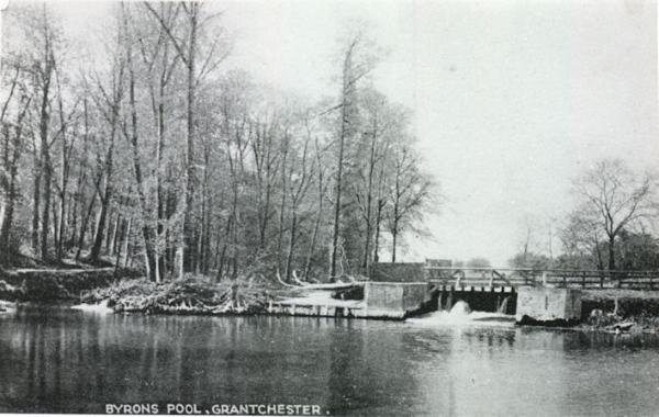
B. Byron’s Pool and Literary Connections
Byron’s Pool was given to Cambridge Council by the Trumpington Hall Estate in 1949 and was established as a Local Nature Reserve in 2005. It is named after Lord Byron, who swam here, as did members of the Bloomsbury Group (Trail 9). The mill pool was more attractive before the weir was rebuilt in 1949, with locals also coming here to swim (now dangerous). There were a number of Medieval mills upriver from Cambridge, including here, mentioned in the Domesday Book , and at Shelford, Hauxton and Grantchester (Trails 7, 8, 9). In The Canterbury Tales , Chaucer wrote about Trumpington, a local mill and Symkyn the dishonest and foolish miller (The Reeve’s Tale). The mill foundations are sometimes visible close to the weir when the water level is low. In the 1800s, there were fish ponds near the river, renovated in 2011, when the new fish pass was also built to help fish migrate.
C. Archaeology of Trumpington Meadows

In the last 20 years, there have been archaeological excavations across this part of Trumpington, revealing evidence of 5000 years of human occupation. In the Neolithic period, there was a circular monument on the ridge, near where the school was built. In the Iron Age, there was an agricultural community in the area now used by the Park & Ride site. In the Roman period, there were farms along the river (stop 5). By the Middle Saxon period, there was a settlement to the south of the current church (stop 3). One of the graves associated with the settlement included the body of a teenage female laid on a bed, wearing a gold and garnet cross. The later village developed north of this nucleus.
D. Trumpington Meadows Country Park
The Country Park includes riverside, meadows, woodland, hedgerows, ponds, open parkland, play areas, walking and cycling trails and bridleway. It has been developed for the benefit of wildlife and for people to enjoy, walk in, play, discover wildlife and art. The park is on land that has been farmed for 1000s of years. For most of that time, the land was used for growing crops and grazing livestock on flower-rich meadows. The riverside part of the park has been turned back into meadows, with fields that continue to have an agricultural link, being managed for hay, with cattle grazing to help keep them flower-rich. The park is managed by the Wildlife Trust, which has been working since 2009 to sow meadows, plant hedges and copses, restore ponds and improve the river for wildlife. The park has been accessible since 2015 and was officially opened in June 2016. The Trust has a base and storage barn at the north east corner of the park.
Additional information
trumpingtonlocalhistorygroup.org
trumpingtonresidentsassociation.org
Wildlife Trust: http://www.wildlifebcn.org/reserves/trumpington-meadows
Byron’s Pool: http://lnr.cambridge.gov.uk/nature_reserve/byrons-pool/
© TLHG and TRA, September 2016.